Zadanie Straż pożarna (str)
Pomóż nam usprawnić bazę zadań!
Fire Brigade
Memory limit: 64 MB
In the capital of Byteotia, Bytau, the layout of streets is highly regular. Every street leads either from north to south, or from east to west. Therefore every north-south street intersects every east-west street in exactly one spot. Furthermore, along every street its successive intersections are exactly 1 km apart.
Bytau is not only the capital, but also one of the oldest cities in Byteotia.
No wonder that there are as many as  historic buildings, each at one of the
intersections.
The City Council cares for their protection very much, and is now concerned
with the risk of fire. Hence they have decided to establish two main fire stations
in the city.
Each monument is going to be protected by the nearest station; by both,
should both fire stations be equally close.
Housing is very dense in Bytau, so Euclidean distance is not the measure of choice. The distance between a monument and fire station should rather be defined as the length of the shortest path along the streets between them.
The City Council has prepared several projects of the stations' location. And you have been asked to determine, for each of them, the number of monuments protected by: the first station only, the second station only, and both stations, respectively.
Input
In the first line of the standard input there are four integers  ,
,  ,
,  and
and  (
( ,
,  )
separated by single spaces and denoting respectively: the number of streets
leading from north to south, the number of streets leading from east to west,
the number of historic buildings in Bytau, and the number of projects proposed by
the City Council.
The north-south streets are numbered from  to
to  , west to east.
The east-west streets are numbered from
  to
to  , north to south.
The intersection of
  -th north-south and
  -th east-west street
will be denoted by the coordinates
  .
.
In each of the following  lines there are two integers
  and
and  (
( ,
,  ) separated by a single space and
denoting the coordinates of the
  -th monument.
No pair of different monuments is located at the same intersection.
Each of the following  lines contains one proposal of the City Council
- four integers
  ,
,  ,
,  ,
,  separated by
single spaces,
  ,
,  ,
,
 .
The coordinates
  and
and  describe
the intersections at which the fire stations are to be located according to
the
  -th proposal (
 ).
).
Output
Your programme should print out exactly  lines on the standard output.
There should be three integers in the
  -th line, denoting:
the number of monuments protected by the first station of
  -th proposal
of the City Council only, the number of monuments protected by the second
station only and the number of monuments protected by both stations,
respectively.
These numbers should be separated by single spaces.
Example
For the input data:
6 5 6 1
1 2
6 5
5 1
3 3
3 4
4 1
2 3 4 3
the correct result is:
1 3 2

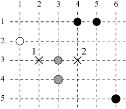
The dashed lines in the figure represent streets, circles - locations
of monuments, while crosses - proposed locations of fire stations.
White circles depict monuments protected by the first station only,
black circles - by second station only, while grey ones - by both stations.
Task authors: Marian M. Kedzierski and Jakub Radoszewski.
Kontakt
In the event of technical difficulties with Szkopuł, please contact us via email at [email protected].
If you would like to talk about tasks, solutions or technical problems, please visit our Discord servers. They are moderated by the community, but members of the support team are also active there.

 English